By Dr Mischa Turschwell
The Belt and Road Initiative is the world’s largest ever infrastructure project, in a new analysis we considered opportunities to deal with its environmental impacts.
China’s Belt and Road Initiative, or the ‘New Silk Road’, is the world’s largest infrastructure development project, aimed at linking Europe and East Africa with Asia. The initiative combines a large network of terrestrial and maritime routes with the intent of linking over 70 countries, at an estimated cost of US$8 trillion by 2049.
The possible environmental impacts associated with the BRI will be trans-boundary in nature and cover enormous areas. This huge development will likely have negative consequences for habitats and biodiversity on land and in the sea.
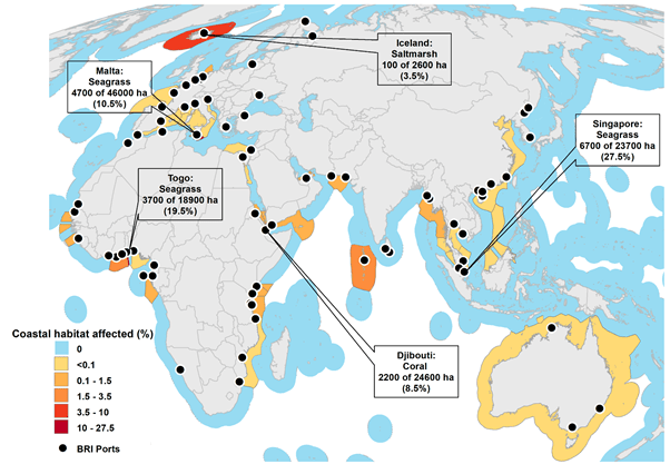
In recent research, we assessed the spatial footprint of the development and expansion of ports associated with the Belt and Road Initiative for coastal wetlands (seagrass, mangrove and saltmarsh habitats), coral reefs, and all threatened marine species that exist near planned developments. We also assessed the impacts of increased shipping traffic on threatened marine species.
We found that the total coastal marine habitat area that could be affected is approximately equal to 69,500 football fields.
We estimated that ports associated with the Belt and Road Initiative could impact approximately 55,000 hectares of seagrass, 8,500 hectares or coral, 4,000 hectares of mangroves and 2,000 hectares of saltmarsh.
We also found that over 400 threatened marine species could be affected by port infrastructure, and more than 200 threatened species are at risk from an increase in shipping traffic and noise pollution.

Mitigating the risks to biodiversity from global infrastructure development can be challenging due to political and socio-economic factors but there are a number of potential solutions to minimise impacts.
For example, dredging activities around ports can be monitored and managed to minimise impacts to ecosystems and species. The frequency and duration, and timing of dredging activities can help to minimise the effect of light limitation on seagrasses and fish species that are known to have vulnerable juvenile stages.
Shipping impacts can be managed by restricting vessel speeds or changing routes, especially during important migratory and feeding seasons for marine mammals.
For the best environmental outcomes, suitable mitigation measures need international coordination, given the near global nature of the Belt and Road Initiative. We suggest that a project of this magnitude provides an opportunity for a central governing body to develop and implement an overarching environmental framework and to implement policy that mitigates risks to biodiversity.
The global integration of conservation measures for the Belt and Road Initiative could ensure the best possible outcomes for biodiversity conservation.
This work appeared in Marine Policy
